Mapping protected and conserved areas reveals the rich stories and multiple perspectives behind the biodiversity
Under the Global Support Initiative for ICCAs, diverse and innovative approaches to mapping are helping to reveal more and more information about ICCAs, which is an abbreviation for the territories and areas conserved by indigenous peoples and local communities.
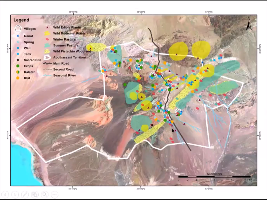
Photo: CENESTA
“Maps are more than pieces of paper, they are stories, conversations, lives and songs lived out in a place and are inseparable from the political and cultural contexts in which they are used” (Warren, 2004).
This initiative, which is moving into its final year, has been funded by the German government, the Global Environment Facility (GEF), and the United Nations Development Programme (UNDP), to form a partnership with the IUCN Global Protected Areas Programme to create the largest global fund for ICCAs. One major part of this work has been to map these territories, which has been led by the UN Environment World Conservation Monitoring Centre (UNEP-WCMC). In addition to hosting the World Database on Protected Areas (WDPA), UNEP-WCMC host the ICCA Registry website, an online information platform for both indigenous peoples and communities and the international conservation community, to recognise and protect the multiple values of ICCAs. It also highlights their contribution to conservation around the world.
The ICCA Registry is a voluntary, peer reviewed avenue for ICCAs, where the communities themselves provide data, case studies, maps, photos and stories which result in useful statistics and analysis on featured ICCAs around the world. This is a major contribution to the achievement of targets contained in the CBD Aichi 2020 framework, in particular Aichi Target 11.
ICCAs are very diverse and can include indigenous territories, indigenous protected areas, cultural land- and seascapes, sacred natural sites, migration routes of mobile indigenous peoples, bio-cultural heritage territories, sustainable resource reserves, and community-managed areas. Those wishing to register on the ICCA registry are encouraged to describe the territory both descriptively and spatially. The description should contain the features of the ICCA, the name and size, the biodiversity found therein and whether or not it receives a legal designation. The case provider should describe how it is governed, whether shared or governed solely by the ICCA, and may include historical information. In terms of spatial information, the location or spatial boundary of the ICCA may be given, if the latter is not possible, the latitude/longitude location or point location is acceptable. UNEP-WCMC has a series of webinars on the ICCA Registry to help anyone interested in getting started, available here in English, Spanish and French. The documents needed to register are available here.
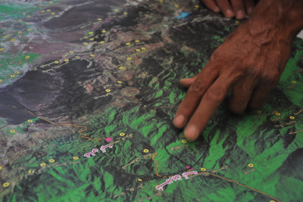 Photo: CENESTA
The second kind of mapping under the project is participatory and/or community mapping. Participatory mapping is a general term to define a set of approaches and techniques that combine the tools of modern cartography with participatory methods to represent the spatial knowledge of indigenous peoples and local communities and sometimes other stakeholders). These maps then represent the place in which the people live, showing the elements that communities themselves perceive as important such as customary land boundaries, traditional natural resource management practices, sacred areas, and so on. CENESTA in Iran, have for example, conducted mapping activities by separate male and female groups showing diverse and gendered resource use, indicating management systems in place on the ground. Mapping can be interactive with scaled paper maps, or use 3D modelling and can also be geo-referenced, to provide rich layered data sets that tell stories about the landscape with its multiple perspectives: spatial, economic, cultural, political, ecological, geological and historical. Mapping can be used for a wide variety of reasons from the empowerment of indigenous peoples and local communities, to advocacy, land use planning, conflict resolution, food security and uncovering past, present and future trends. For more information on participatory mapping, check out the webinar here.
Related content
Países como Brasil, Argentina, Uruguay, Paraguay, Bolivia y Chile no son ajenos a las sequías....
El "Proyecto de Turismo Sostenible en Áreas Protegidas en un Mundo Post-COVID", liderado por la...
La Oficina Regional de la UICN para América del Sur se unió este año a la celebración de la Semana...

Suscríbase a un boletín de la UICN.